TerrainCAD 1.0
TerrainCAD is a terrain generation, editing and modeling software. Powered by TerrainLib, TerrainCAD employs blazing fast and robust algorithms to create and modify terrain meshes in no time.
Last update
7 Dec. 2005
Licence
Free to try |
$195.00
OS Support
Windows
Downloads
Total: 785 | Last week: 3
Ranking
#265 in
Others
Publisher
Sycode
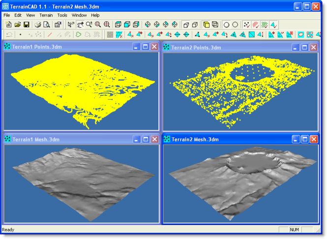
Screenshots of TerrainCAD
TerrainCAD Publisher's Description
TerrainCAD is a terrain generation, editing and modeling software. Powered by TerrainLib, TerrainCAD employs blazing fast and robust algorithms to create and modify terrain meshes in no time. The capabilities of TerrainCAD can be broadly classified as (1) Terrain Generation, (2) Terrain Editing, and (3) Terrain Modeling
Terrain Generation: TerrainCAD creates a terrain mesh from a set of unorganized survey points, breaklines and contours. The terrain mesh is created as a Delaunay Triangulation, which is regarded as the best method to create a terrain mesh from unorganized point data. TerrainCAD can also generate a terrain mesh directly from contours only. Breaklines can be employed to give TerrainCAD the intelligence to create superior terrain meshes that accurately resemble the actual landscape to be recreated.
Terrain Editing: Often terrain meshes need to be manually edited for various reasons. TerrainCAD makes this very easy by offering a host of terrain mesh editing commands. TerrainCAD has very useful commands to edit vertices, edges and faces of a terrain mesh.
Terrain Modeling: TerrainCAD also offers several mesh modeling commands. These commands help in altering the general topology of the mesh thereby making it suitable for further operations.
Look for Similar Items by Category
Feedback
- If you need help or have a question, contact us
- Would you like to update this product info?
- Is there any feedback you would like to provide? Click here
Popular Downloads
-
 Kundli
4.5
-
 Macromedia Flash 8
8.0
-
 Cool Edit Pro
2.1.3097.0
-
 Hill Climb Racing
1.0
-
 Cheat Engine
6.8.1
-
 Grand Theft Auto: Vice City
1.0
-
 Grand Auto Adventure
1.0
-
 Tom VPN
2.2.8
-
 HTML To PHP Converter
6.0.1
-
 Zuma Deluxe
1.0
-
 Netcut
2.1.4
-
 Windows XP Service Pack 3
Build...
-
 Vector on PC
1.0
-
 Minecraft
1.10.2
-
 Ulead Video Studio Plus
11
-
 PhotoImpression
6.5
-
 Street Fighter 3
1.0
-
 Auto-Tune Evo VST
6.0.9.2
-
 Iggle Pop
1.0
-
 C-Free
5.0


